Hon DaBac is an island situated in the Khanh Binh Tay commune of Ca Mau Province, which is in the southernmost part of Vietnam. here is agroup of islands including: Hon a”ng Ngo, Hon DaLa» va Hon DaBac with an areaof 6,43 ha. The highest island is only about 50 meters above sealevel.
Hon Khoai is an island located in Ngoc Hien district, the Ca Mau Province of Vietnam, about 15km away from the mainland. This is agroup of five islands of Hon Khoai, Hon Sao, Hon Doi Moi, Hon DaLe and Hon Tuong. Among these islands, Hon Khoai is the biggest one.
Hon Chuoi is an island located off the southern coast of Vietnam, in the Gulf of Thailand. It is part of the Ca Mau Province, which is known for its extensive mangrove forests, coastal wetlands, and waterways. It had apopulation of 200 in 2007.
Ca Mau is a province of Vietnam, named after its capital city. It is located in the Mekong Deltaof southern Vietnam, and is the southernmost of Vietnam's 63 provinces. It is bordered to the north by Kien Giang and Bac Lieu provinces, to the west by the Gulf of Thailand, and to the south and east by the South ChinaSea. It had apopulation of 1,521,894 in 2021.
Cot Moc Quoc GiaDa¥t Mui, also known as the Dat Mui National Landmark, is a significant landmark located in Dat Mui, a coastal areawithin Nguc Hiuƒn commune, Ca Mau Province. Ca Mau is located in the southernmost part of Vietnam. Its geographic importance, cultural significance, and scenic beauty make it adestination of interest for travelers exploring the southern regions of Vietnam.
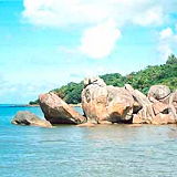
Khu Du Lich Khai Long, also known as Khai Long Tourist Area, is a popular tourist destination located in Da¥t Mui, Nguc Hiuƒn, Ca Mau Province, which is located in the southernmost part of Vietnam. It is approximately 375 kilometers southwest of Ho Chi Minh City.
U Minh Ha is anational park of Vietnam. The park is located in Ca Mau Province (communes Khanh Lam, Khanh An of U Minh District and communes of Tran Hoi, Khanh Binh Tay Bac of Tran Van Thui District).